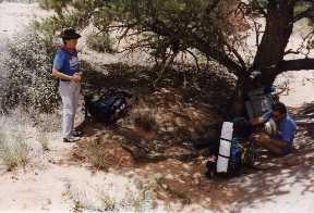
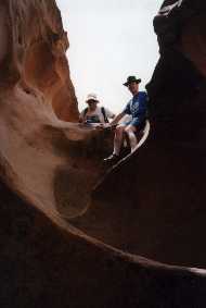
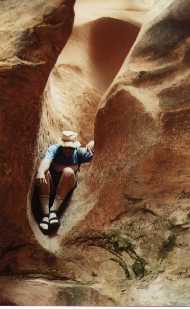
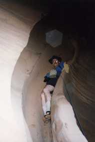
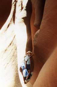
The author (left) and John Beach on the hike into Jack's Canyon
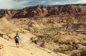
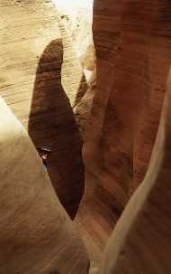
This picture shows the author exploring some of the high ground above Jack's Canyon (pictures by Tom Katonak).
 Jack's Canyon is not the real name of this canyon. This canyon is located
somewhere on the Colorado Plateau but I have changed the name to disguise
its location. Several people who have seen this web page asked that I disguise
the name in order to avoid attracting crowds of people to this area and
destroying the true wilderness nature of the area. I agree with them -
there have been too many wonderful places that received publicity which
attracted less considerate or inexperienced hikers. The result has either
been a degradation or the outright closure of these areas. So, if you truly
value the wilderness experience and challenge, study your topo maps and
head out on your own. Good Luck!
Jack's Canyon is not the real name of this canyon. This canyon is located
somewhere on the Colorado Plateau but I have changed the name to disguise
its location. Several people who have seen this web page asked that I disguise
the name in order to avoid attracting crowds of people to this area and
destroying the true wilderness nature of the area. I agree with them -
there have been too many wonderful places that received publicity which
attracted less considerate or inexperienced hikers. The result has either
been a degradation or the outright closure of these areas. So, if you truly
value the wilderness experience and challenge, study your topo maps and
head out on your own. Good Luck!
The standard route into this seldom visited slot canyon is from the downstream end, via boat. From there adventurers head upstream into the slot canyon. I understand the lower sections are very narrow and challenging with several waterfalls (6) to bypass and many deep dark narrows.
However, the upper section of Jack's Canyon is apparently only accessible overland. To the best of my knowledge the upper narrows have only been visited by two other parties (others may have been there but I saw no evidence and would be delighted to hear from anyone who has been there). In one canyon hiking guide book the author gives a second hand account of two trips into the upper narrows. When we did the upper narrows in 1997 we found a rock bolt and a rope into a large pool. Except for this single rope, in an area well over 100 square miles we found no evidence of human presence - not a trail, footprint, or empty beer can.
Three of us (Tom Katonak, John Beach, and myself) entered the upper narrows of Jack's Canyon in June 1997. We turned north off the paved road and headed up a dirt road, probably 15 miles, to a small creek. After dropping into the creek we continued up the stream bed several miles to the junction of two small streams. We left our 4WD at this point at continued some 5 miles north through beautiful desert scenery to a pass over into the Jack's Canyon basin. We dropped down another mile into the upper reaches of Jack's Canyon and set up base camp on a bench just upstream from the upper narrows.
|
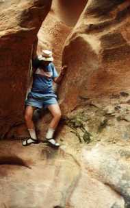
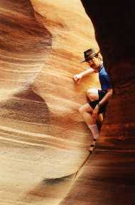
The author (left) and John Beach on the hike into Jack's Canyon |
This picture shows the author exploring some of the high ground above Jack's Canyon (pictures by Tom Katonak). |
 The day we back packed in we explored the very upper most part of the
upper narrows. This provided some very narrow, twisty, narrows, but they
were not too deep and did not provide too many obstacles. We did encounter
one sheer drop of about 15' into a pool, with no place to tie off a rope
above, so we back tracked a bit, climbed up out of the canyon and found
a route back down into the canyon a few hundred yards further on. There
were several pools and this easy little section did provide some opportunity
to practice stemming across the canyon to maintain dry feet.
The day we back packed in we explored the very upper most part of the
upper narrows. This provided some very narrow, twisty, narrows, but they
were not too deep and did not provide too many obstacles. We did encounter
one sheer drop of about 15' into a pool, with no place to tie off a rope
above, so we back tracked a bit, climbed up out of the canyon and found
a route back down into the canyon a few hundred yards further on. There
were several pools and this easy little section did provide some opportunity
to practice stemming across the canyon to maintain dry feet.
We found no springs in the upper section of the canyon, but there were numerous stagnant pools. The one closest to our campsite was full of tadpoles and had an abundance of insect life on the surface. We affectionately named this "frog shit pond". Tom's Katadine (sp?) filter proved up to the task of producing drinking water from this, but required constant cleaning of the filter (every 2 quarts). Insects proved to be no problem so rather than cram 3 of us into my backpacking tent, I chose to sleep under the stars.
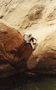
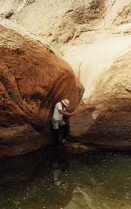
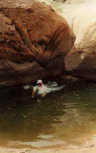
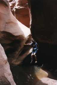
 The next day brought the main assault on the upper canyon. We took light
day packs, 6 ropes, an inflatable mattress to ferry gear across deep pools,
and lunch. What a day! We skirted the drop off we found the previous day
and again descended into the canyon. The canyon immediately got deep and
narrow and never let up. I think we only made about 4 miles in the canyon
all day. We started with some large potholes (photo at right by Tom Katonak)
we had to shimmy down into and back up the and out the other side. Some
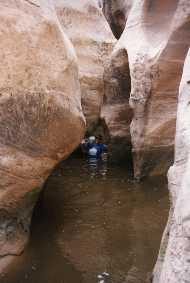
narrow twisty sections followed, and then the only pool that was over our
heads. We had to chimney down a crack into the pool, into water over our
heads, and then swim the pool (that's John crossing the pool in the 3 photos
below).
The next day brought the main assault on the upper canyon. We took light
day packs, 6 ropes, an inflatable mattress to ferry gear across deep pools,
and lunch. What a day! We skirted the drop off we found the previous day
and again descended into the canyon. The canyon immediately got deep and
narrow and never let up. I think we only made about 4 miles in the canyon
all day. We started with some large potholes (photo at right by Tom Katonak)
we had to shimmy down into and back up the and out the other side. Some
narrow twisty sections followed, and then the only pool that was over our
heads. We had to chimney down a crack into the pool, into water over our
heads, and then swim the pool (that's John crossing the pool in the 3 photos
below).
On the other side we continued through numerous other sections with standing water varying in depth from waist to mid-chest deep (of course we didn’t know what sort of holes might be in the bottom as we walked through these).
 |
 |
 |
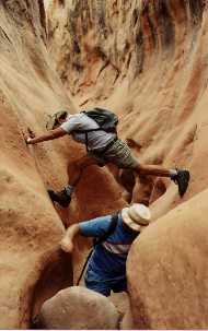
 From here it just continued to get narrower, rougher, and deeper. Every
time we got through something and said, "It can’t get any tougher
than this", it did. These two pictures show John shimmying down a
crack onto a narrow ledge above a larger drop off. First he works his way
down the crack to the ledge (left) and then works his way around to a way
down off the ledge (right).
From here it just continued to get narrower, rougher, and deeper. Every
time we got through something and said, "It can’t get any tougher
than this", it did. These two pictures show John shimmying down a
crack onto a narrow ledge above a larger drop off. First he works his way
down the crack to the ledge (left) and then works his way around to a way
down off the ledge (right).
 In several places we had to chimney down a crack and then drop a couple
of feet into a pool (me in the photo taken by Tom on the left). In these
cases we tied off a rope above so we could climb back up into the crack
if we had to come back that way (we did). There was one 50 yard straight
section where it was so narrow I had to carry my day pack next to me and
side step through. The photo on the right shows Tom just entering this
section before it got so narrow he had to turn sideways.
In several places we had to chimney down a crack and then drop a couple
of feet into a pool (me in the photo taken by Tom on the left). In these
cases we tied off a rope above so we could climb back up into the crack
if we had to come back that way (we did). There was one 50 yard straight
section where it was so narrow I had to carry my day pack next to me and
side step through. The photo on the right shows Tom just entering this
section before it got so narrow he had to turn sideways.
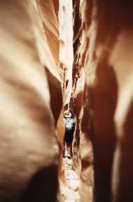
 After this the canyon got so convoluted that we came to a chute going
down into darkness. The chute went down at a fairly steep angle (70 degrees?)
so Tom started chimneying down, with feet against one side and back braced
against the other. To make things more interesting, it curved around as
it went. I stood above and held a flashlight so Tom could see where he
was going. After he got down a few feet he started seeing light coming
from the other side and eventually dropped into a small room sized pot
hole. Tom took this photo of me coming down the chute. At the end of the
chute there is about a 4' drop to the floor of the pot hole, but the chute
gets narrow enough I got stuck in the very bottom part and had to pry myself
out before dropping. The floor of the pothole was covered with boulders
about 1/2 the size of a bowling ball. I could just imagine them whirling
around the room during a flood, providing a "stone washed" texture
to anything that happened to be in there at the time!
After this the canyon got so convoluted that we came to a chute going
down into darkness. The chute went down at a fairly steep angle (70 degrees?)
so Tom started chimneying down, with feet against one side and back braced
against the other. To make things more interesting, it curved around as
it went. I stood above and held a flashlight so Tom could see where he
was going. After he got down a few feet he started seeing light coming
from the other side and eventually dropped into a small room sized pot
hole. Tom took this photo of me coming down the chute. At the end of the
chute there is about a 4' drop to the floor of the pot hole, but the chute
gets narrow enough I got stuck in the very bottom part and had to pry myself
out before dropping. The floor of the pothole was covered with boulders
about 1/2 the size of a bowling ball. I could just imagine them whirling
around the room during a flood, providing a "stone washed" texture
to anything that happened to be in there at the time!
 After we all got down and climbed out the other side, we continued on.
We finally got stuck when we came to a deep hole with a pool in the bottom.
Tom went down a rope, about one story into the dark room with the pool.
On our side of the room, the pool was waist deep for Tom - I remember looking
way down and seeing his hat as he walked around. The pool fell off toward
the other side till it was over his head. The exit on the far side was
above a sheer wall that Tom could not get up: if the water level had been
lower, he could have climbed on one of us to get up while we stood, or
if the level had been higher, he could have reached the exit while swimming.
Unfortunately, the water level was wrong for both of these. At this point
we had been in very serious deep narrows for probably the better part of
a mile - continual twisting, potholes, and funnels we had to negotiate
to get back. We had barely seen the sky for the last several hours - sort
of makes you wonder what the clouds are doing up there.
After we all got down and climbed out the other side, we continued on.
We finally got stuck when we came to a deep hole with a pool in the bottom.
Tom went down a rope, about one story into the dark room with the pool.
On our side of the room, the pool was waist deep for Tom - I remember looking
way down and seeing his hat as he walked around. The pool fell off toward
the other side till it was over his head. The exit on the far side was
above a sheer wall that Tom could not get up: if the water level had been
lower, he could have climbed on one of us to get up while we stood, or
if the level had been higher, he could have reached the exit while swimming.
Unfortunately, the water level was wrong for both of these. At this point
we had been in very serious deep narrows for probably the better part of
a mile - continual twisting, potholes, and funnels we had to negotiate
to get back. We had barely seen the sky for the last several hours - sort
of makes you wonder what the clouds are doing up there.
By this time it was getting on in the afternoon, so we reluctantly began to retrace our steps. We eventually got to an exit point and climbed out of the canyon. Wanting to see how far we had gotten, we continued down stream on the high ground adjacent to the canyon. We eventually came to a small side canyon which we clambered down into. This quickly became so narrow (with lots of twists to contort our bodies) that we could barely squeeze through without our packs. I have an image in my mind of John laying on his back on a rock fin trying to squeeze over it with the opposite wall pressing down on him from above. Then it opened out for a few feet and - dropped about 150’ straight down into the main canyon. Bummer!
However, we figured we were just below where we had gotten stuck by the pool deep in the main canyon, and since Tom had a GPS unit along, we could plot our position on a topo map to within about 50 yards. We were about a ½ mile above the furthest point that the guidebook author had gotten going upstream, so we think we got through 95% of the toughest part of the upper canyon. We are talking about returning at some point and coming up from downstream to see the lower (and we think easier) lower canyon.
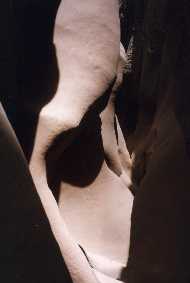
The following are just a few miscellaneous pictures in the canyon which show some of the rock texture and color.
 |
 |
 |
 |
All of the pictures here were taken with hand held 35 mm. Except for the pictures attributed to Tom Katonak, I took the pictures with ASA 200 film and a 50 mm f/1.4 lens. Some of the pictures were at 1/15th of a second, braced against a rock wall. |