 The
Nazca Lines
 The
Nazca Lines
A Non-mysterious, Non-extraterrestrial Explanation
By Joel M Williams ©2014
A
free pdf version can be downloaded at General Science Journal - click here
Introduction
The Palpa, Peru geoglyphs1 are placed on hillsides similar in vein to the etchings by prehistoric humans on the walls of cave for easy viewing. The Nazca Astronaut and Baby Condor are in this vertical genre. The Nazca lines and figures, on the other hand, are not so readily viewed. Much has been posited by those who endorse extraterrestrial influence that these lines and figures are the inhabitants reaching out to them2. This paper demonstrates with figures that these line whether straight and narrow or broad like rectangles and trapezoids are simply the application of basic engineering knowledge to effect management of meager water resources. The skills used to manage water flow also provided the means to create the nature figures that have been found. How these nature figures were created with significant precision without being viewable has been a source of conjecture. This paper illustrates that they could simply have been created by citizens who staged them on a well-defined, viewable grid and then celebrated by marching into the open desert and taking up corresponding target locations. Since many figure areas were used more than once and many different figures are still found even after many centuries, celebrations could easily have occurred annually.
The Palpa-Nazca Region
The following figures3 are presented to give those not-so-familiar-with-the-area a sense of what it looks like. The first shows a portion of the Peruvian coast with the 100 km2 or so Nazca desert region marked where many lines and figures are found.
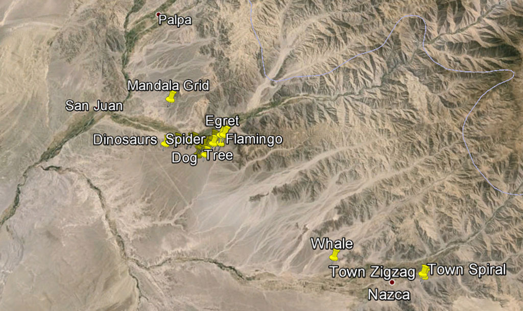
The second figure provides a higher magnification of the Palpa-Nazca area. Natural water flow lines from the hills east are clearly evident. The Palpa geoglyphs are located predominantly on the walls of the hills from Palpa to San Juan. The Nazca figures and lines are primarily in the area below the dip in the green line, a fertile valley east of San Juan. Although lines can be found down to the next green line, no Nazca nature figures occur in the desert much below "Dog". The Nazca figures are fairly concentrated when you consider all the land around them.

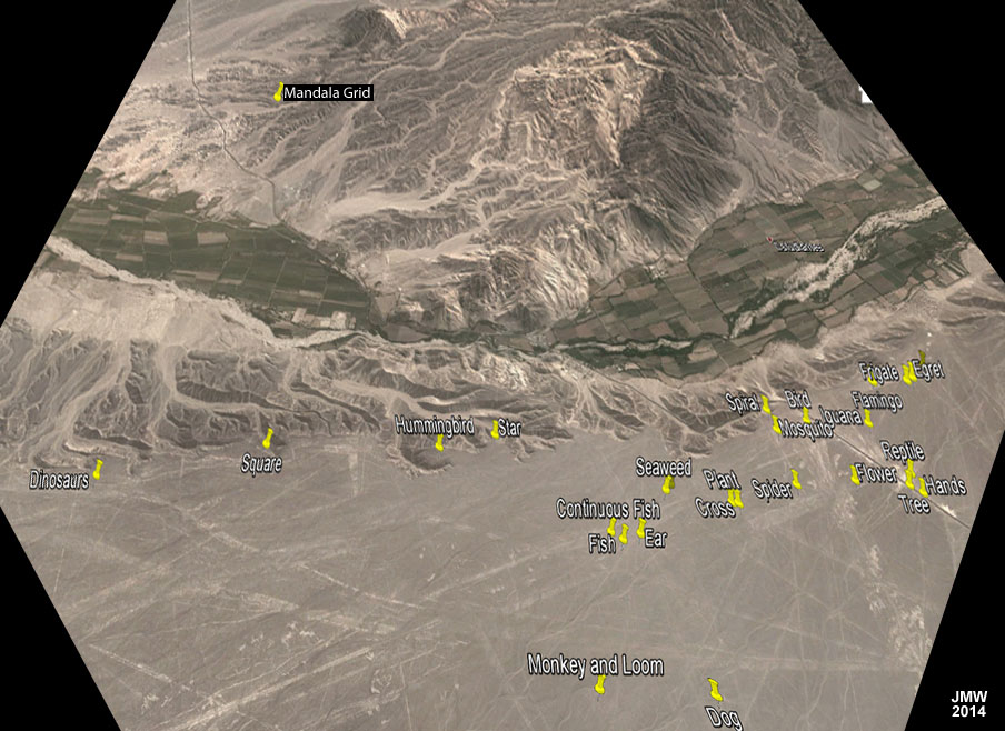
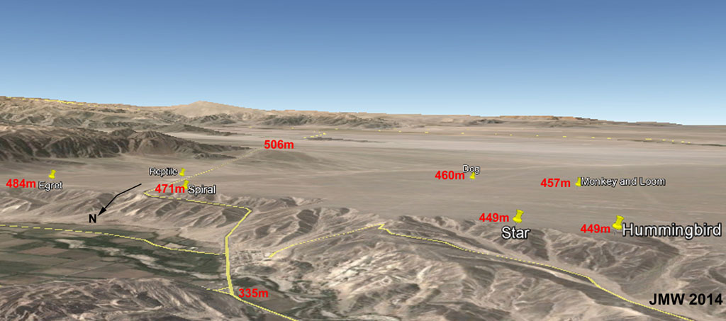
The following figure shows the location of many of the Nazca figures a little differently. Pan Am Sur is the thin line starting in the upper left (coming from Palpa), wandering through the narrow part of the green farmland, rising up in the middle and turning sharply eastward past "Spiral", before turning SE and running through "Reptile". Linear lines that seemingly go every which way can be seen in the foreground.
When looking at a magnified satellite view, artifacts make the desert region appear (as in the previous figure) to be surrounded by small hills. The street view below, looking south, shows this desert area, however, is a very flat, high plateau.
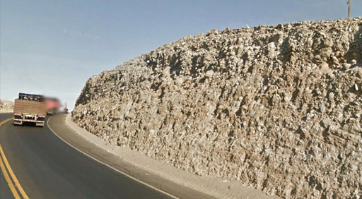
The Nazca Desert looks very much like what would have occurred with a vast plastic or slurry aggregate flow. The composition of the terrain, as indicated in the cut for PanAm Sur going south up onto the Nazca desert from the valley (see figure on the right) would support this. Note its consistent, small rock texture.
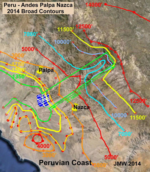
An analysis of the contour lines (below) of the region indicates that this terrain was created by a massive "Debris avalanche landslide"4 that originated 35 miles east, high in Andes mountains. The contour lines in the figure are broad and span the valleys that have been cut by the river west of Palpa and that north of the lined Nazca Desert (marked in blue). This is to emphasize the terrain of the landslide flow that occurred in the area marked by the green rectangle. The high (11500' elevation), fan-like plateau just below 12500' and south of the landslide area is striking. When the landslide occurred, it gouged out material similar to that north of the landslide area. In doing so, the landslide would have perform a massive "strip mining" operation and carried its debris downhill. The coastal hills provided a dam to allow the smooth, flat Nazca Desert area to be formed.
The Linear and Rectangular Nazca Lines
The problem with water flowing into a desert region is that it is mainly thin and meager or in flash floods. The Nazca lines are efforts to harness meager flows into narrow channels and direct them into productive fields over an area where the drop in elevation is only ~0.7% for 7km! The engineering feat requires multi-fold understanding: water flows down-hill, the short distance between two point is a line-of-sight (straight) line, several feed lines provide redundancy for sporadic water supplies, and the shortest distance to achieve delivery to a point may be by connecting a new channel to a channel that is already in place.
Water delivered to a field will usually be to a narrow inlet with subsequent spreading; thus, trapezoidal fields. Conversely, the wide end could also be the collection part to feed a narrow funnel. Rectangular fields are likely in more level areas. Field directions can be in any direction: mostly down-grade, but also cross-grade. All are found in the Nazca desert. The figure below illustrates the features of water management to fields in the area between the "Hummingbird" and the "Square". The areas in the upper part of the figure are where the smooth desert has been eroded away and the terrain drops ~100 meters! These are not hills! Beware of deceptive satellite imagery.
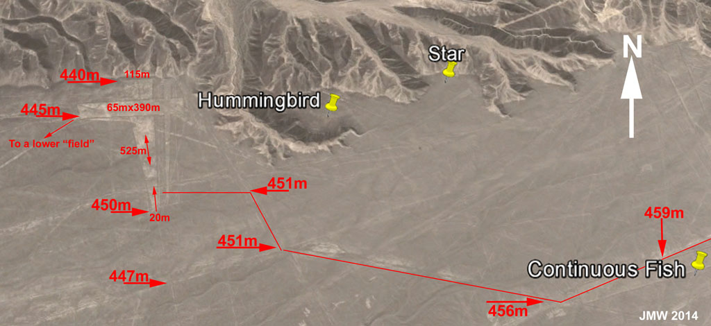
The first thing to note is that there are a number of possible channels from the east to supply water for the fields to the west of the Hummingbird figure. The one shown has the greatest drop in elevation. Note that there is little drop in elevation for the second half of it. The S-to-N trapezoidal field, which has a 2% down slope (10m over 525m), was probably the first as the E-W rectangular field cuts across it. The trapezoidal field stops just before the smooth desert drops into the valley below. As good engineering would have it, there is a second feed to the modest-sized rectangular field [65m x 390m (6.25 acres)]. An outlet at the SW end of this rectangular field leads to another rectangular field further down slope.
As the desert surface shifts and water feeds vary, the very shallow aqueduct system would require extensive reworking! There seems to be nothing here that justifies ascribing these lines and shapes to anything other than diligent attention to diverting water to rectangular and trapezoidal areas. These areas could have been used to grow crops in bygone days (unlikely considering the soil), or to store water for use on the farms in the valley, or as evaporation ponds for salts, or, most likely, as a strategy to either "pan" for gold5a, copper or obsidian nuggets5b, or to prevent effluents from flowing onto the valley farms below. All seem rational. Their use as landing strips for extraterrestrial aircraft is not.
The Nazca Nature Figures - Peaceful Celebrations
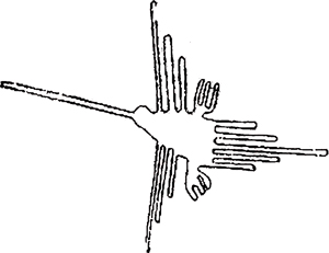
Unlike the water-management lines and regular 2D geometric shapes, the nature figures (lots of birds) present a very different set of "lines". Like the 180-ft "Spider" shown below, many of the figures are becoming faint even with restricted access now imposed. One web site6 has the Lines and Figures highlighted with bright white overlays that make locating them easy.
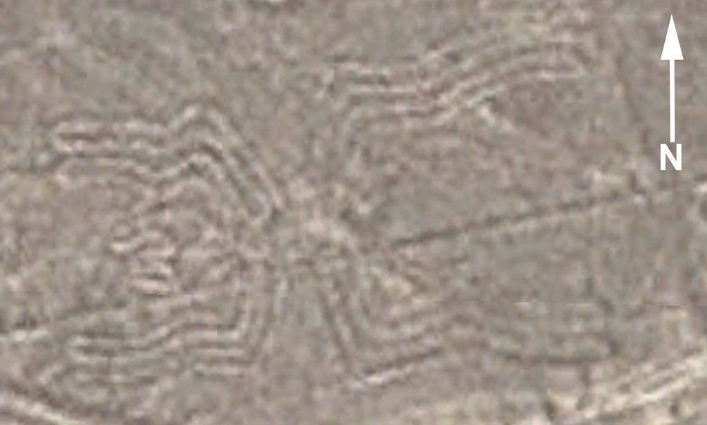
These figures have been the source of much conjecture about their having been created for extraterrestrials who would see them from aloft as they can not be viewed from ground level. The remainder of this paper will demonstrate that the means to design and then create them "blindly" on an open field were well within the skill level of the human citizenry that lived in the region.
The nature figures demonstrate a citizenry in tune with their surroundings and ecology. These figures would indicate peaceful, non-hallucinogenic, celebrations by the masses. Once "etched" into the desert by moving rocks, they would provide venues for additional activities, such as therapeutic "walking-the-lines" in pairs or alone.
How could such well-defined figures be "blindly" created in the desert? By the "marching band" technique used by US university and high school bands7. The key to successful formations is learning to hit target locations on a well-defined grid and then applying the target's x,y-movements on an open field. For the US marching bands, the football gridiron is the practice grid. For the citizens of the Palpa-Nazca region, the "gridiron" would have been the Mandala Grid!
The Mandala Gridiron
The Mandala Grid (also know as the "Cross") is a fairly precise grid on a plateau between the Nazca desert and Palpa. See the figure below. Its use and purpose beyond that of a gridiron will not be presented here, although it seems to be simply that - a grid. What will be presented is its favorable features for the design and practice of "marching band" formations.

The Google Earth view of the grid is shown in the figure below left. The overlay analysis on the right indicates that the major grid lines form a 8x8 chess or checkerboard pattern. The size of the square pattern is 180 feet on a side (deJong's value8) and is positioned slightly off "Google earth" north.
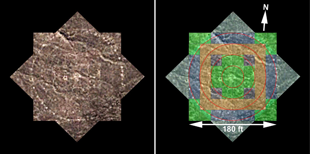
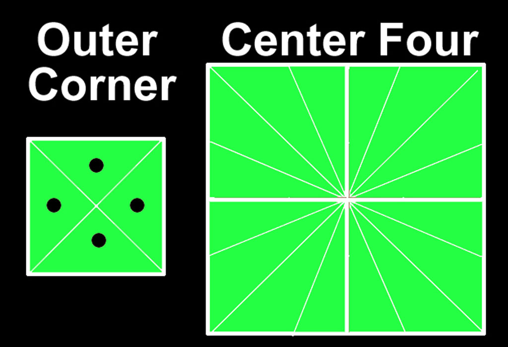
Discerning the units that gave this 180-ft dimension has been surmised elsewhere8. Individual grid squares have additional features, as deJong has carefully documented8. A principle feature is the diagonals to the corners (see the figure below) that emphasize "halving" and possibly "quartering" of the squares. The grid does not appear to be divided finer nor is any decimal character indicated. The circles could easily be formed by a "rope" reaching the outer edge of the horizontal squares and rotated around the center point. Conjectures about relating radial and rectangular coordinates would be just that. What the grid provides is a large, 180' x 180', staging area with well-defined coordinates.
What is also special about the Mandala Grid is its location. For use as a design/staging platform, the designs need to be viewable. The following figure shows how the grid sits in its surroundings. Only a few elevated hills are found to the north. The plateau drops offs in every other direction. From a flat region on a nearby hill, staging on the grid, ~100 feet below in elevation, can be easily viewed.
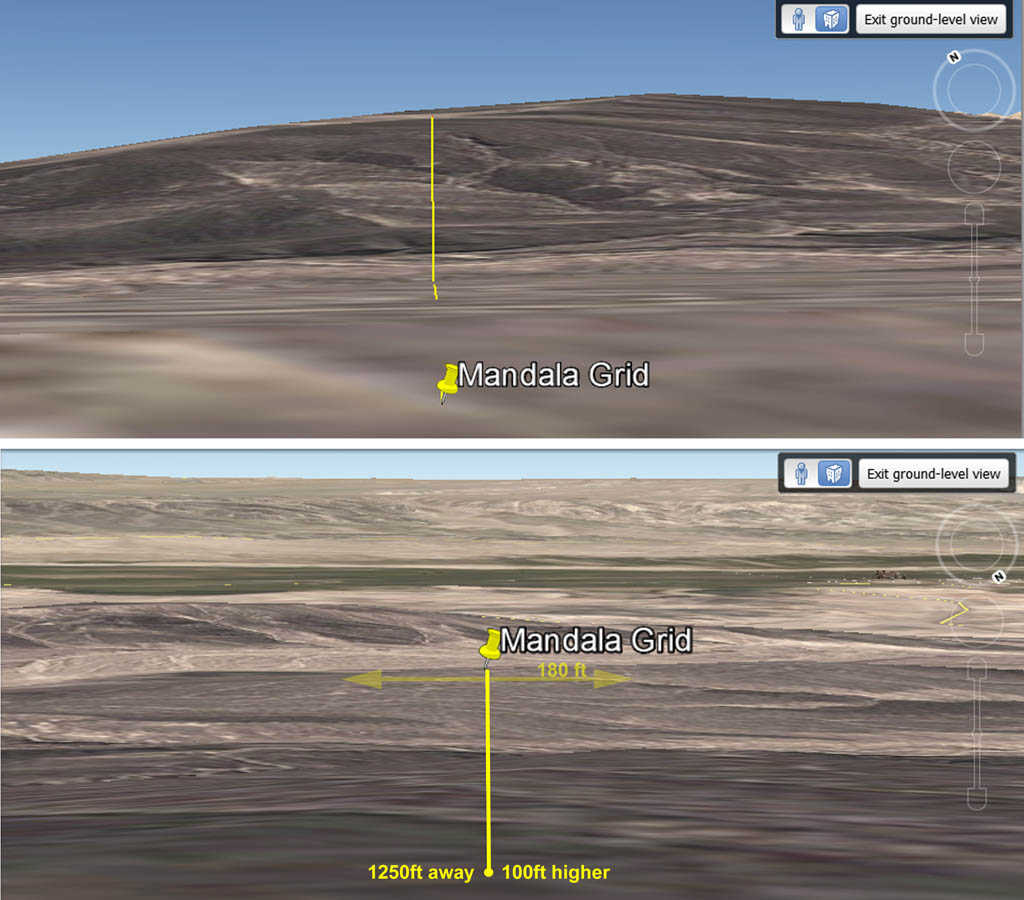
The needed gridiron stage was created in a favorable location. In addition to being on a flat expanse and having an elevated view point, the grid has been located in an area that has been relatively free of weathering, as indicated by its lasting for many centuries. The question now: how do the various nature figures relate to this grid?
Staging Nature Figures on the Mandala Gridiron
The Mandala Grid is fixed in size at 180 ft x 180 ft. The size is large enough to accommodate many people for design creations. The nature figures, on the other hand, are not fixed in size. The "ear" is smaller than the full grid, spanning 78 ft, while the "Frigate Bird" is many time larger, spanning 1060 ft! The Mandala Grid features "whole", "halve" and "quarter" blocks. Members of the "marching cast" would certainly be able to do whole-number multiples of their x-y movements from a center position, but not likely fractions thereof. Thus, a singe step can become 2, 3 or more. Using this strategy, figures could easily be replicated and magnified. To test this concept, the size of many of the figures in the Nazca desert region has been determined and related to how they would be staged on the Mandala Grid. The information is presented in the table below. The % dev from 1/2 squares is based on the design extremes being set to the nearest 1/2 square. The average error is just a bit greater at ~2.3% (the two smallest excluded), if the designs are actually scaled to the nearest whole unit of squares instead of halves.
|
Figure |
Location |
Size (ft) |
% |
X |
Size on Grid (ft) |
Squares |
% dev from 1/2 squares |
|
|
|
|
|
|
|
|
|
|
Mandala Grid |
14° 38.648'S, 75° 10.272'W |
180 |
1.00 |
1 |
|
22.5 |
|
|
|
|
|
|
|
|
|
|
|
Ear |
14° 41.880'S, 75° 8.120'W |
78 |
0.43 |
1 |
78 |
3.47 |
1.0 |
|
Square |
14° 41.502'S, 75° 9.797'W |
80 |
0.44 |
1 |
80 |
3.56 |
1.6 |
|
Continuous Fish |
14° 41.875'S, 75° 8.235'W |
130 |
0.72 |
1 |
130 |
5.78 |
3.7 |
|
Fish |
14° 41.904'S, 75° 8.192'W |
135 |
0.75 |
1 |
135 |
6.00 |
0.0 |
|
Seaweed |
14° 41.698'S, 75° 7.984'W |
160 |
0.89 |
1 |
160 |
7.11 |
1.6 |
|
Hands |
14° 41.667'S, 75° 6.834'W |
165 |
0.92 |
1 |
165 |
7.33 |
2.2 |
|
Dog |
14° 42.386'S, 75° 7.849'W |
172 |
0.96 |
1 |
172 |
7.64 |
1.9 |
|
Spider |
14° 41.650'S, 75° 7.343'W |
180 |
1.00 |
1 |
180 |
8.00 |
0.0 |
|
Cross |
14° 41.736'S, 75° 7.603'W |
180 |
1.00 |
1 |
180 |
8.00 |
0.0 |
|
Plant |
14° 41.733'S, 75° 7.628'W |
180 |
1.00 |
1 |
180 |
8.00 |
0.0 |
|
|
|
|
|
|
|
|
|
|
Vulture |
14° 41.672'S, 75° 7.962'W |
230 |
1.28 |
2 |
115 |
5.11 |
2.2 |
|
Iguana |
14° 41.358'S, 75° 6.932'W |
230 |
1.28 |
2 |
115 |
5.11 |
2.2 |
|
Whale |
14° 48.991'S, 74° 59.687'W |
230 |
1.28 |
2 |
115 |
5.11 |
2.2 |
|
Tree |
14° 41.636'S, 75° 6.876'W |
260 |
1.44 |
2 |
130 |
5.78 |
3.7 |
|
Spiral |
14° 41.293'S, 75° 7.366'W |
260 |
1.44 |
2 |
130 |
5.78 |
3.7 |
|
Flower |
14° 41.625'S, 75° 7.093'W |
262 |
1.46 |
2 |
131 |
5.82 |
3.0 |
|
Hummingbird-2 |
14° 41.047'S, 75° 6.550'W |
280 |
1.56 |
2 |
140 |
6.22 |
3.7 |
|
Town Spiral |
14° 50.036'S, 74° 54.192'W |
300 |
1.67 |
2 |
150 |
6.67 |
2.6 |
|
Hummingbird |
14° 41.529'S, 75° 8.933'W |
316 |
1.76 |
2 |
158 |
7.02 |
0.3 |
|
Monkey |
14° 42.405'S, 75° 8.350'W |
320 |
1.78 |
2 |
160 |
7.11 |
1.6 |
|
Egret |
14° 41.120'S, 75° 6.634'W |
363 |
2.02 |
2 |
182 |
8.07 |
0.8 |
|
|
|
|
|
|
|
|
|
|
Condor |
14 41'50.09"S, 75 7'34.59"W |
435 |
2.42 |
3 |
145 |
6.44 |
0.9 |
|
Dinosaurs |
14° 41.640'S, 75° 10.510'W |
500 |
2.78 |
3 |
167 |
7.41 |
1.2 |
|
Bird |
14° 41.356'S, 75° 7.203'W |
550 |
3.06 |
3 |
183 |
8.15 |
1.9 |
|
|
|
|
|
|
|
|
|
|
Reptile |
14° 41.585'S, 75° 6.848'W |
620 |
3.44 |
4 |
155 |
6.89 |
1.6 |
|
Loom |
14° 42.405'S, 75° 8.350'W |
680 |
3.78 |
4 |
170 |
7.56 |
0.7 |
|
Mosquito |
14° 41.400'S, 75° 7.349'W |
740 |
4.11 |
4 |
185 |
8.22 |
2.8 |
|
|
|
|
|
|
|
|
|
|
Flamingo |
14° 41.143'S, 75° 6.828'W |
810 |
4.50 |
5 |
162 |
7.20 |
2.9 |
|
|
|
|
|
|
|
|
|
|
Frigate |
14° 41.138'S, 75° 6.667'W |
1260 |
7.00 |
7 |
180 |
8.00 |
0.0 |
|
|
|
|
|
|
|
|
|
|
Star |
14° 41.462'S, 75° 8.689'W |
Irreg spokes |
|
|
|
|
|
|
Town Zigzag |
14° 50.179'S, 74° 54.136'W |
Irregular |
|
|
|
|
|
|
|
|
|
|
|
|
AVE |
1.7 |
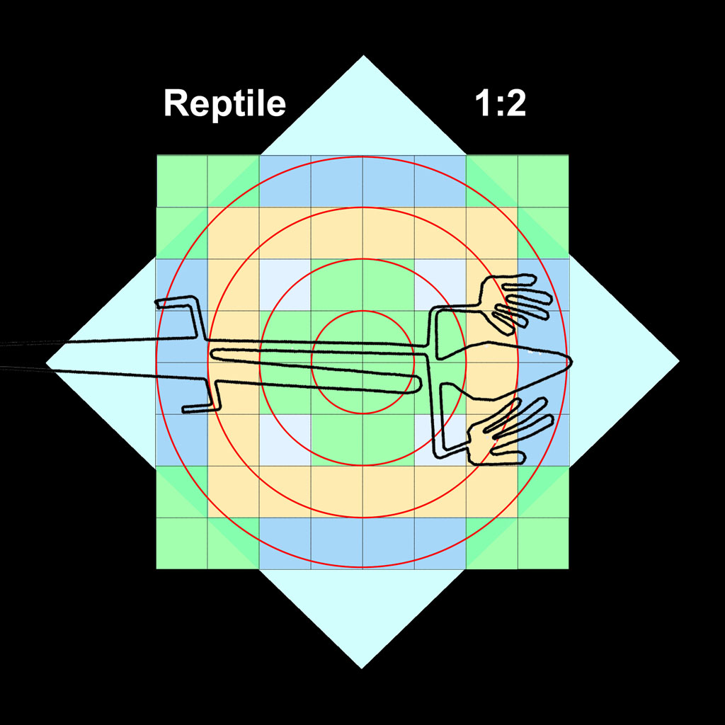
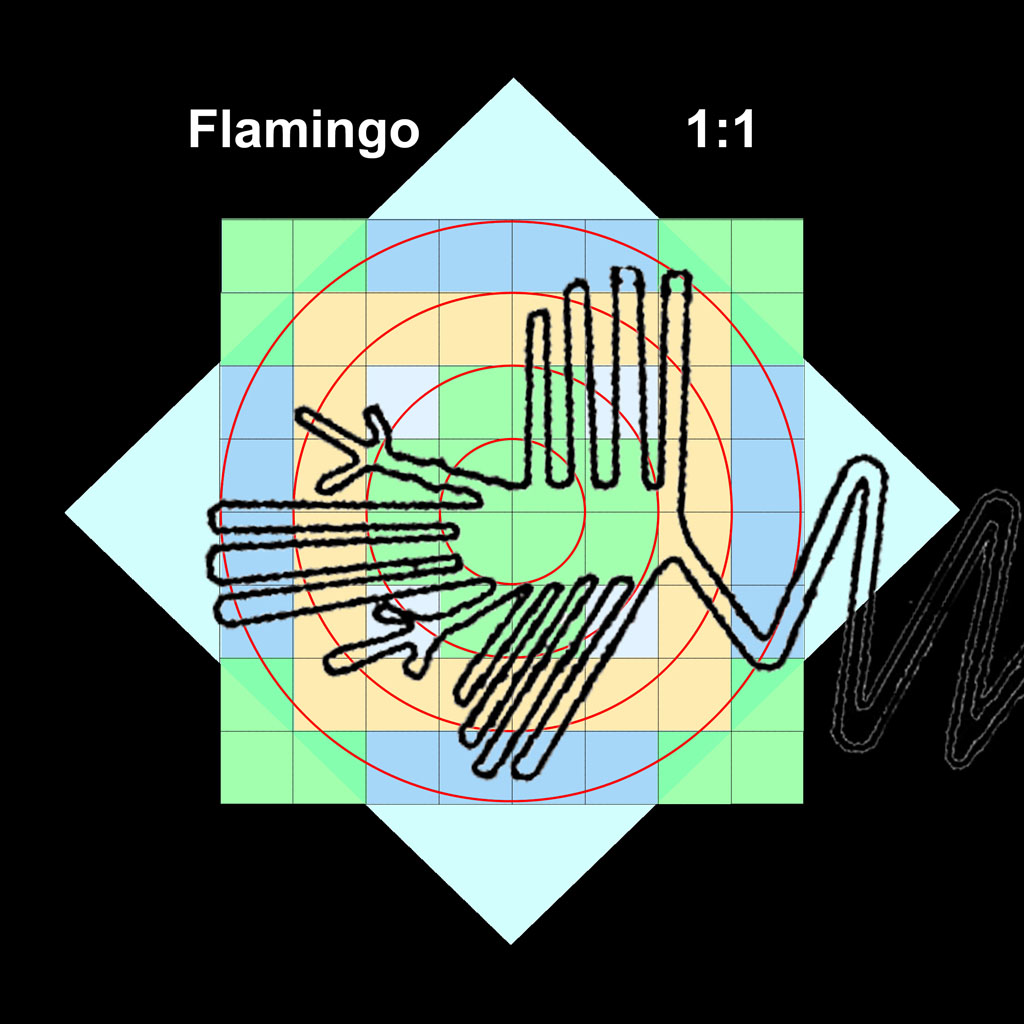
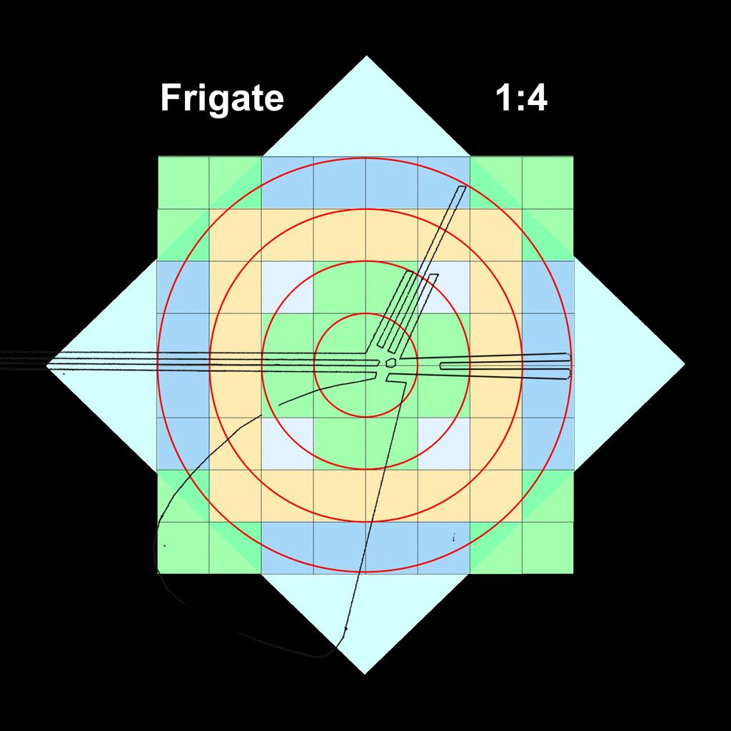
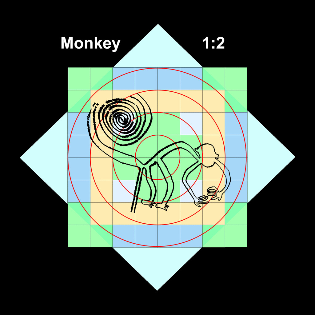
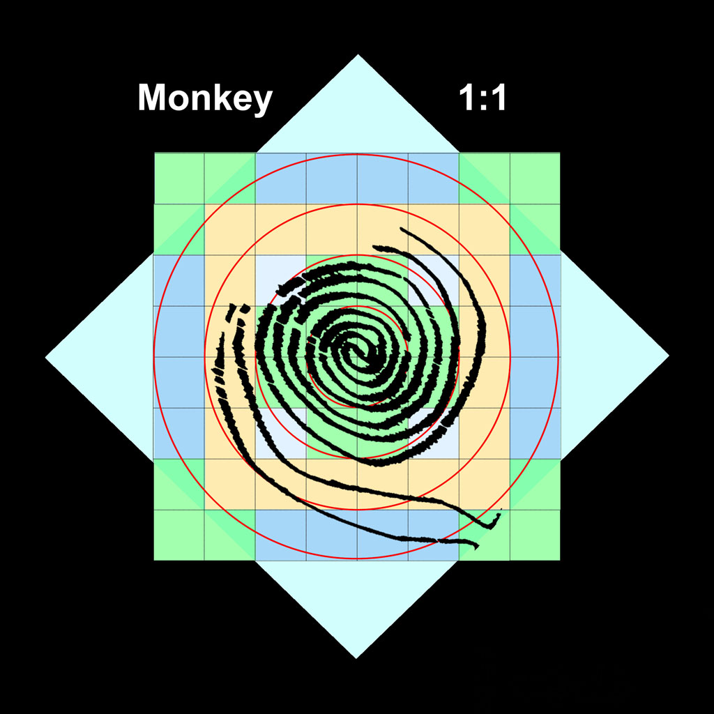
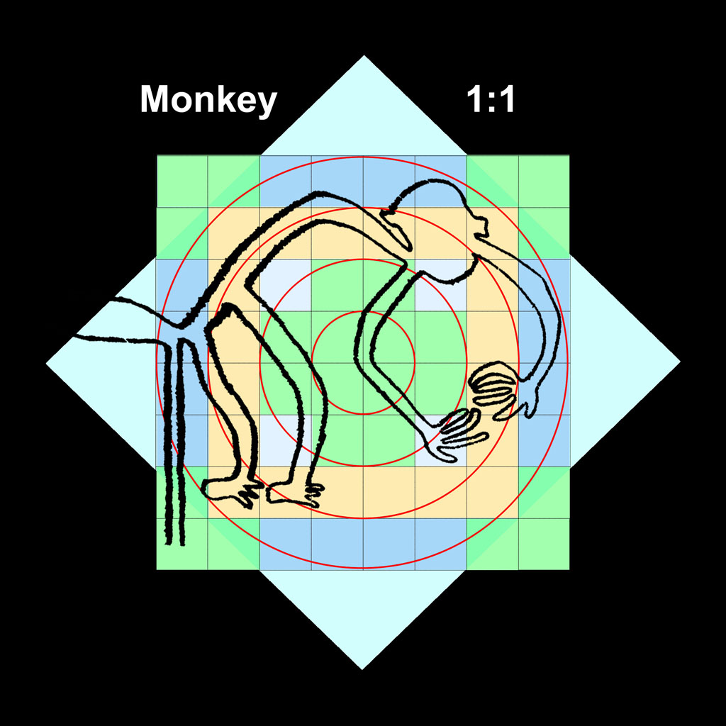
That the nature figures could be transferred from the Mandala Grid stage to the desert with whole-number accuracy indicates the dedication of the "marching band" of performers to replicate their target locations. While the desert figures appear precise, they are not likely to have been "perfect" replicates of the Mandala Grid designs! Nearly so would still have been nice! Below are some of the nature figures as they would be scaled on the Mandala Grid. Most of the figures scale 1:1 or 1:2. The 1:5 and 1:7 figures entail very long bird beaks!
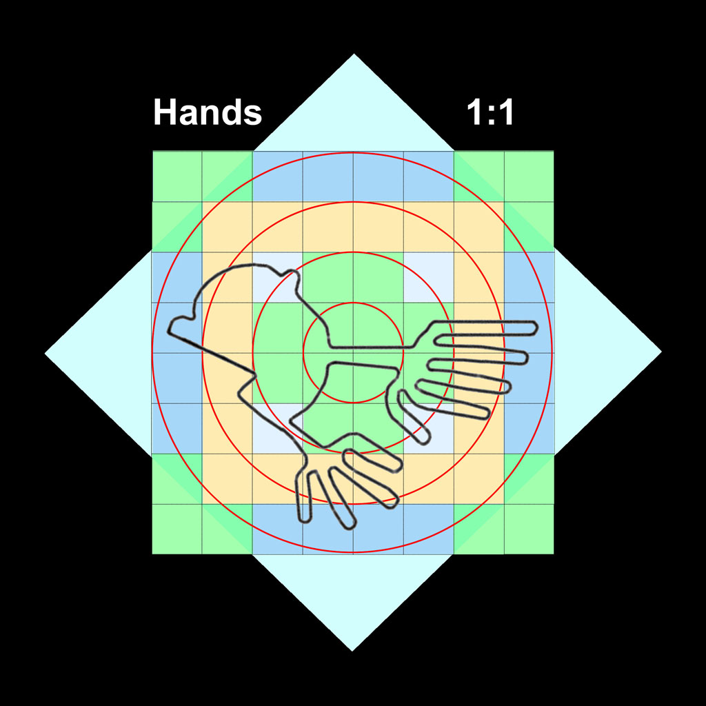
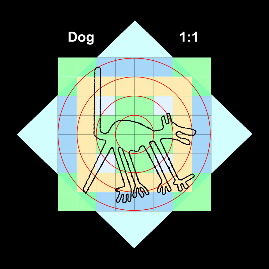
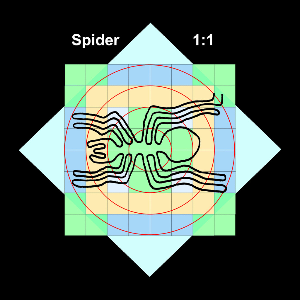
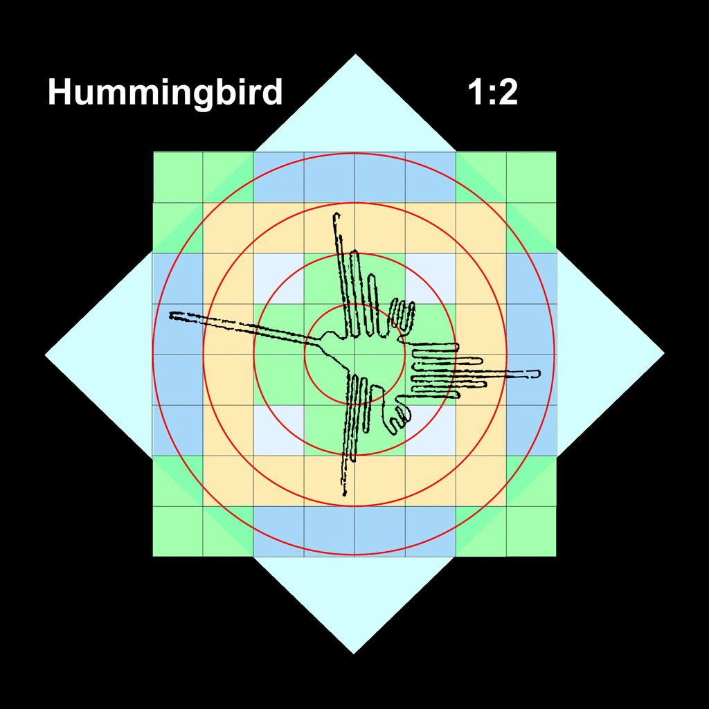
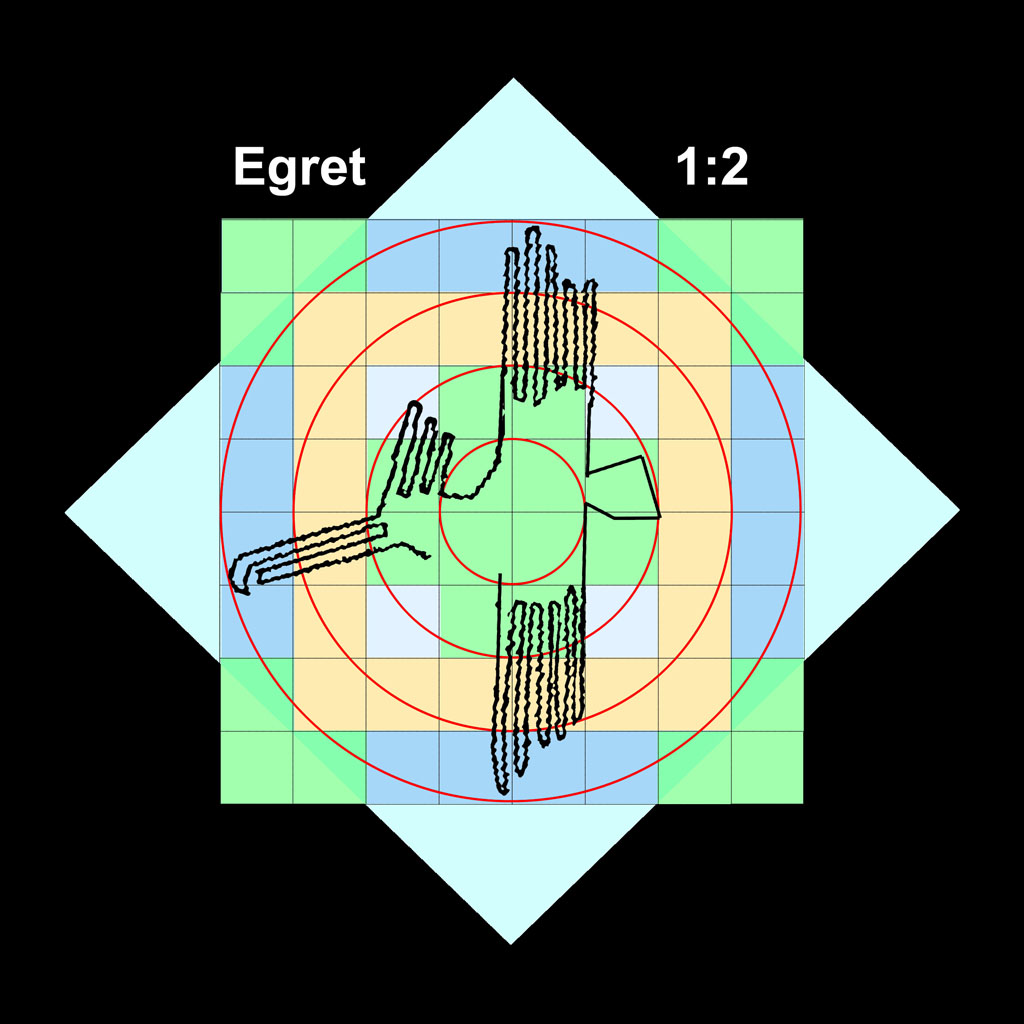
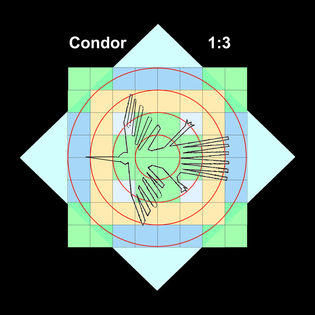
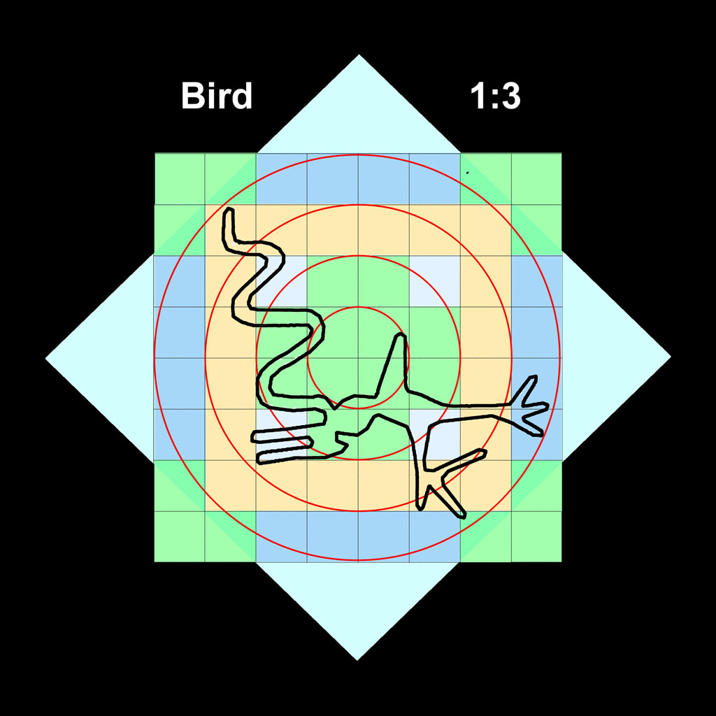
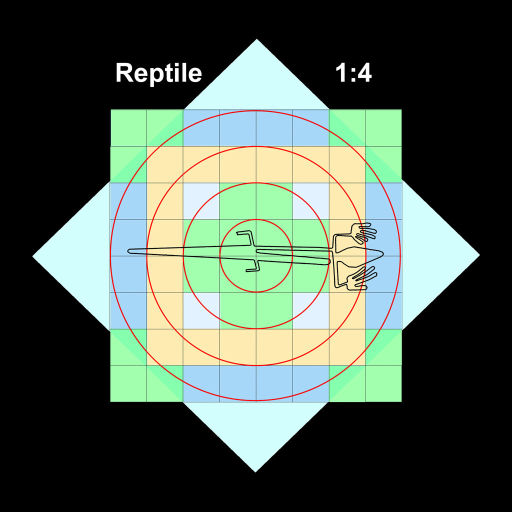
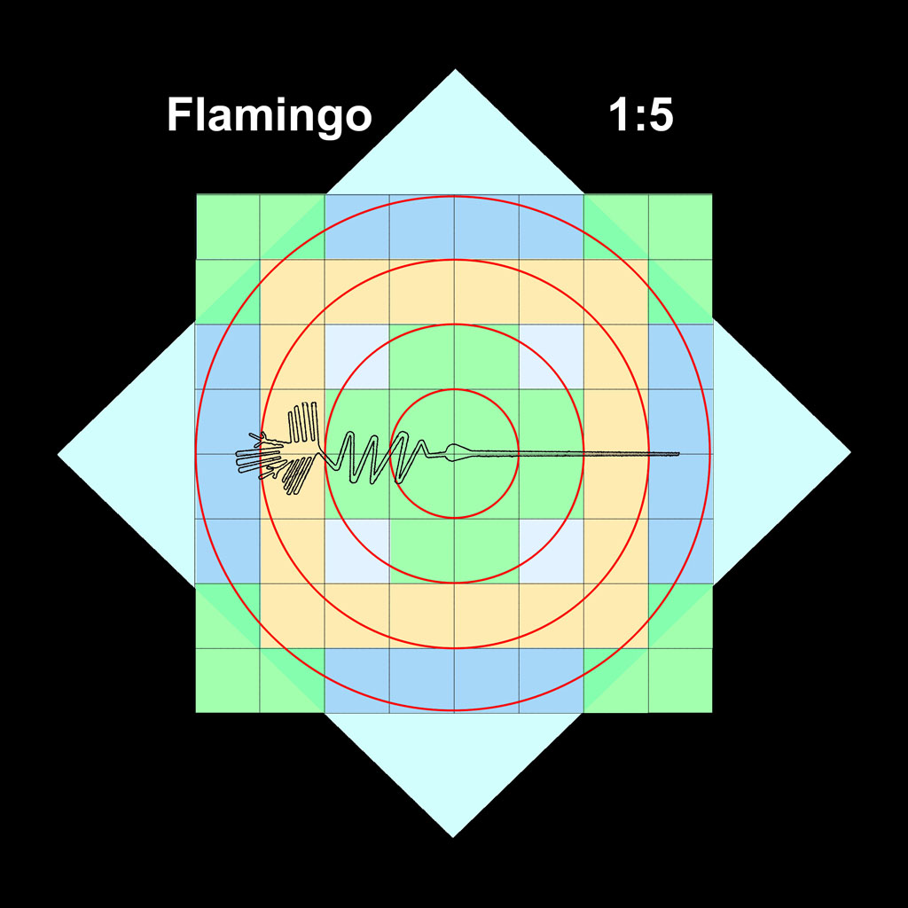
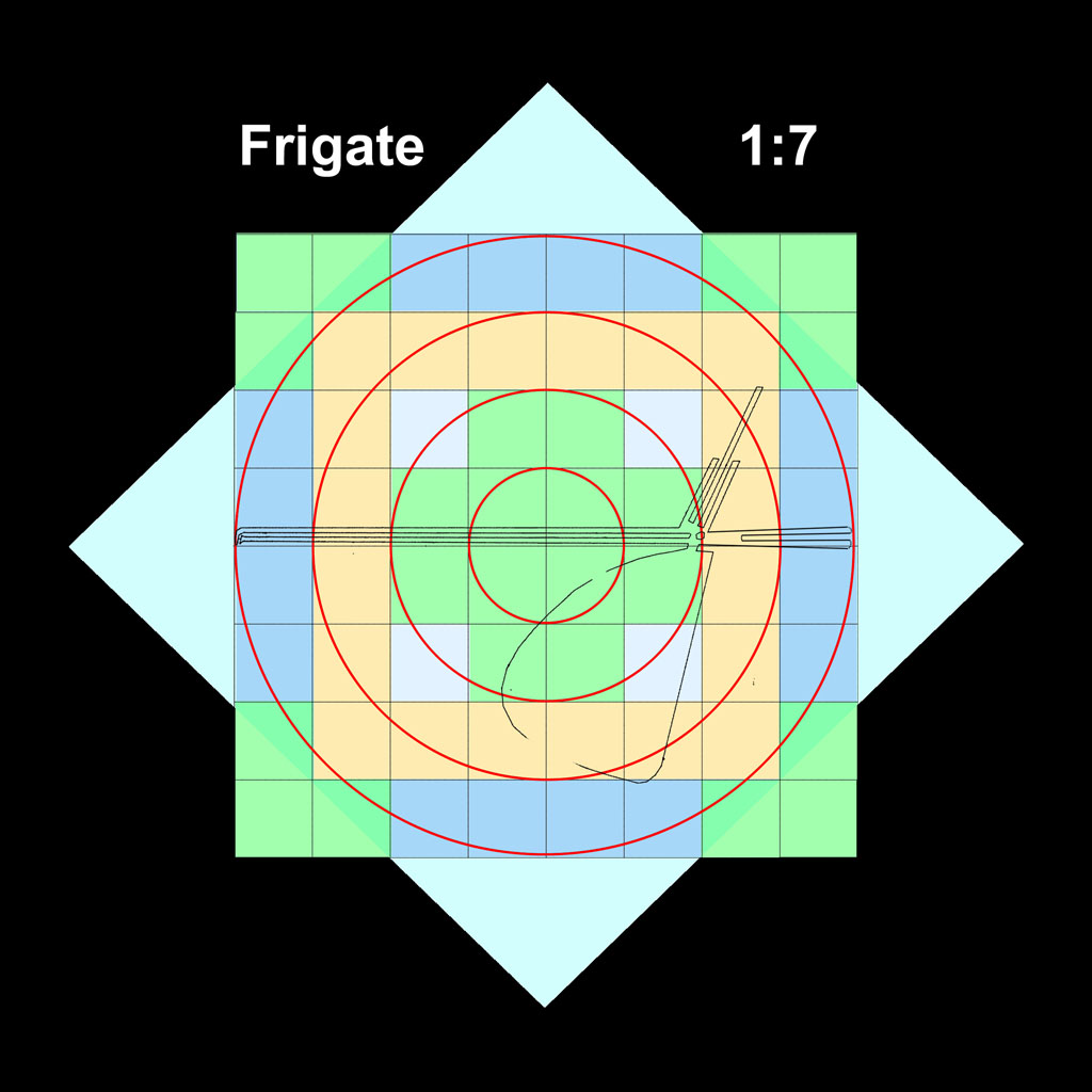
The long linear, zigzag and loop portions might not have been scaled on the grid (see below), as they could be added easily as line-of-sight extensions or wandering to meet as would likely occur for the "Frigate" bird.
The monkey seems to be two separately generated figures joined
together. Note the bulge between the monkey's body and the spiral tail.
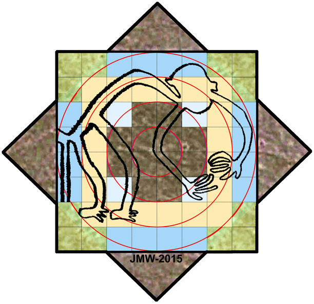
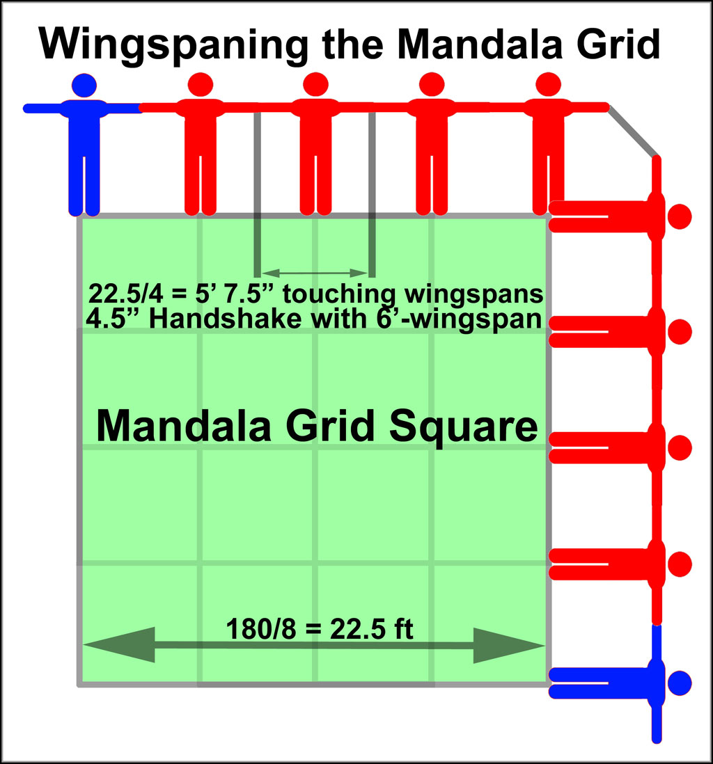
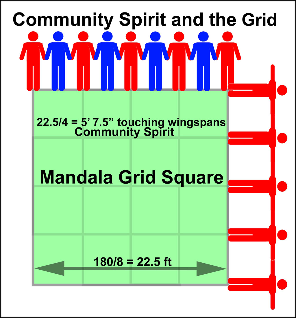
The scaling of the Mandala Grid has been related to those at other ancient sites using modern and ancient units8: meters, feet, Royal Egyptian Cubits, Solomonic Cubits/Sacred Cubits, Remens, Megalithic Yards, Mayan Hunabs, and Sumerian Feet. The figure on the left below offers a different scaling scenario that is based on touching wingspans of pre-Incas. The two red images in the upper right corner are the same person. A 5' 7.5" wingspan would be equivalent to a 5' 6" (1.68m) person based on the relationship between height and wingspan9. For community spirit activities, an addition person would fit very easily between them with hands joined leisurely beside each as the figure on the right suggests.
The Nazca figures have continuous loops which suggests that the participants are joined in a celebratory continuum. The Spider figure below illustrates how this continuum would have been effected.
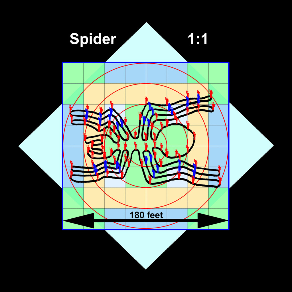
The desert replications of the grid design would most likely be based on a single, straight, line-of-sight line with a center location marked where the figure would be located. Movements would be those set by the Mandala Grid - left or right moves off the line at the appropriate distance from the center point. The figure on the right indicates that ~100 "signal men" would be needed to define the spider accurately. The "red signal men" would take up the critical outer junctures in the desert. Those at U-turns would face the center point to provide left-to-right-hand connections10) for loop continuity throughout the figure. Their spots would have been at whole, halve, or quarter Mandala Grid points or multiples thereof. The "blue signal men" would occupy inner critical junctures and align with the "red men". Citizens would fill the spaces with left-to-right alignment between the "signal men". The continuous path of the figure is ~1740 ft (0.33 mile or 0.53km) long11. If the figure contained just enough people for their wingspans to touch, ~300 of them would be needed12. As indicated above, a very leisurely community-spirit continuum would contain 600 people cozily quartered for a figure this size. What results is a situation wherein each participant occupies only a 3' x 3' segment of the figure! Ceremoniously, and without significant effort, each would participate in the creation of the figure by clearing away the desert stones and smoothing the little area around them. With the figure's path established, they and others who were not involved in forming the figure could now "walk-the-lines" of the figure's continuous maze. Environmental conditions have not been severe enough for over a millennium to eradicate the paths of many of their creations.
Summary
Occam's razor is a useful scientific axiom: choose the simplest, unadorned, explanation of the data. Invoking extraterrestrial intervention for something that can be explained by simple application of earthly human knowledge at the time when that data was generated is stretching credibility far beyond rationality!
While the lines and figures in the Palpa-Nazca region of Peru are fascinating, their creation is not beyond the technical skills that the citizens of that area would have possessed. The linear and 2D features would have been created for the management of water - a scarce resource in a desert environment. The multitude of observed lines attests to the many efforts that were made over many years to effect this management.
The nature figures appear to be the creation of a citizenry in tune with the world around them. The means to blindly create large figures on a desert plateau was clearly available to them in the form of a well-defined grid - the Mandala Grid. This grid allowed them to design and stage figures that could be previewed before they were executed on the unruled desert plateau. The creation of the figures would have been celebratory with the created figures available for further enjoyment, communion, and therapy by "walking their lines".
There are many unexplained things in this world, especially those that would require technical skills thought not to exist when they happened, but the Palpa-Nazca lines and figures should not be among them. When those claiming the existence of extraterrestrial aliens continue to use these lines and figures in efforts to validate their claims, they demonstrate a clear lack of objective credibility and demean the creativity of humankind.
Addendum
My document was created to show the relationship of the Nazca nature figures as "whole number" replicates of the Mandala Grid and the participation of citizens in their creation. This addendum addresses another option/opinion.
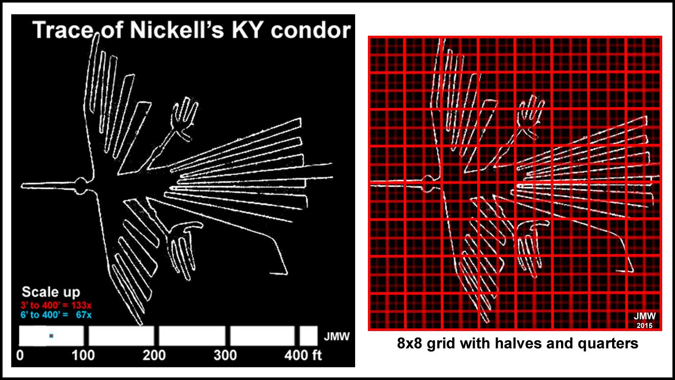
Nickell13 and his 5 relatives, using a "Blue Print", did a very impressive recreation of the Nazca Condor on a 400 sq ft field in Kentucky. Nickell stated that he did not think the figures were created on a grid, but then proceeded to generate the field image by a method that simulated a grid: grid point = f(x,y) with x measured from the tip of the nose, y measured off an axis running through the nose in the "Blue Print" and both scaled by a factor(s) that produced the desired point in the field. The table on the right gives the scale-up for several different size "Blue Prints".
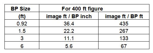
Modern measuring devices make scale-up easy. While much has been made of the pre-Inca foot (Nickell used 12.68"), the Mandala Grid would indicate no such fineness of dimension. The Mandala grid emphasized whole, half and quarter units of a large dimension: the edge of one of the 8x8 Mandala squares (22.5-ft modern). The Mandala Grid clearly indicates that the pre-Inca knew about the diagonal of a "square". Having helped build houses with my father, foundations were not laid out with T-squares, but rather with the Pythagorean formula. We used the 3-4-5 "triangular" method scaled to 10s of feet, as it was easy to remember; the pre-Incas would simply have used the triangle of a "square" without knowledge of the Pythagorean formula.
I have retraced Nickell's Condor image and demonstrated the scale-up from 3' or 6' in the left on the figure below. Very impressive. Nickell indicates that some "6-ft square" areas were found near some of the figures. The Mandala Grid emphasized that the pre-Incas thought in terms of an 8x8 grid. I have placed a 8x8 grid with half and quarter subdivisions over his Condor. Critical points are almost entirely on the grid intersects. Facile scale-up of this less-refined small grid to the field image is clearly possible. The scale-up factor is the relevant issue. Since the Nazca image are multiples of the Mandala Grid, a single conversion factor (or its multiple) must have been used, if these small grids are what was scaled up. Best guess? Scaling factor = whole multiples of 1/2 of a Mandala Grid square (modern 11.25-ft; 2 Inca wingspans). The pre-Incas probably used hand-to-hand people instead of twine to complete the image; as indicated in my previous narrative. Could the "6-ft squares" have simply been the location of an elevated platform for "the conductor" and local dignitary viewing? Not much reason for it to have been left in-place for a long time.
References
1 Sedov, S., Moiseenko, D. (2012), Geoglyphs in Palpa Valley, South America, Peru - A 360° Aerial Panorama, http://www.airpano.com/360Degree-VirtualTour.php?3D=Palpa-Lines-Peru3 All images were been obtained with Google Earth and edited with Photoshop. 4 For an introduction to landslides, see Highland, L.M and Bobrows, P., "The Landslide Handbook—A Guide to Understanding Landslides", http://pubs.usgs.gov/circ/1325/pdf/Sections/Section1.pdf
5b Mining in the Nazca region - Pre-Inca and now.Illegal mining for gold has been so extensive and destructive that the Peruvian government banned it in April 2014. Illegal operations involved an estimated 40,000 illegal miners and produced about 20% of Peru's gold exports. For reference to this information and pictures of "panning" in shallow ponds, see: http://www.theguardian.com/world/gallery/2014/may/03/illegal-gold-mining-peru-in-pictures. The News pictures presented would suggest that the ancient people might have been a bit tidier!
Stöllner, Thomas, Reindel, M, Gassman, G,
Gräfingholt, B and Cuadrado,J (2013)
Precolumbian Raw-Material Exploitation in
Southern Peru - Structures and Perspectives,
Chungara Revista de Antropología Chilena, 45, 1, 105-129 (2013);
http://www.redalyc.org/pdf/326/32626321001.pdf.
The paper describes mining activities in the Palpa-Nazca region from 8000BC to
1180AD;
Eerkens, J.W.,Vaughn, K.J, and Grados, M.L., "Pre-Inca mining in the Southern Nasca Region, Peru",
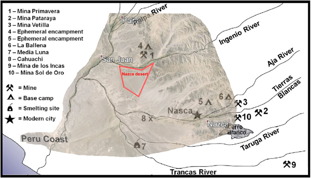
(The figure below left is ref 5b2's Fig1 with the Nazca Desert and mountain topography to the east overlaid.)
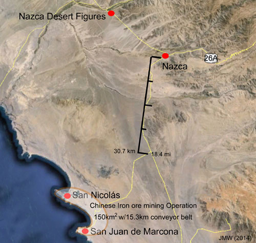
The figure above right shows the region of the massive (150km2) Chinese Shougang Hierro Peru magnetite mining operation that is 35-40 mi south of the Nazca Desert region marked in the left figure above.
8 Allen, Jim (2012) Nazca Lines – Enigma of the Sun-Star and Cross (Mandala); http://blog.world-mysteries.com/science/nazca-lines-enigma-of-the-sun-star-and-cross-mandala/. de_Jong's copyrighted figure analysis of the Mandala grid is included; Allen's assessment of the linear unit that best fits the Mandala grid is also included. 9 Elert, Glenn (ed), Size of a Human: Body Proportions, http://hypertextbook.com/facts/2006/bodyproportions.shtml 10 Left hand-to-right hand connections would be needed whether pre-Incas people were left-handed or right-handed to coordinate the correct looping. As a note, the pre-Columbian Incans appear to have considered left-handed people to be lucky with one of their rulers, Lloque Yupanqui, said to be 'left-handed' (http://anthropologyproject.weebly.com/sinistrally-speaking-language-and-lefties.html). On the other hand, pre-Columbian skull injuries were mainly left/frontal suggesting that they were inflicted by right-handed warriors (http://www.kimmacquarrie.com/skull-surgery-among-the-incas/; Andrushko, V.A., and Verano, J.W., "Prehistoric trepanation in the Cuzco region of Peru: A view into an ancient Andean practice", American Journal of Physical Anthropology, 137 (1), p4–13 (2008)). 11 The length of the spider's continuous path using an opisometer (Op`i*som"e*ter) or curvimeter, a 15"x24" tracing of the spider, was 1743ft ± 14ft for 7 measurements. Cutting the path into 72 segments and attempting to correct visually for curvature when aligning them in Photoshop overestimated the path by 8%: 1880ft.Typically, each band member has an assigned position in each formation. When learning positions for drill, an American football field may be divided into a 5-yard grid, with the yard lines serving as one set of guides. The locations where the perpendicular grid lines cross the yard lines, sometimes called zero points, may be marked on a practice field at eight-, four-, or two-step intervals.
12 A "rounded number" is stated as the path length of the traced, faint figure could easily be 3% too high. The "touching (5'7.5") wingspan" for 1740-ft is 309 people. The number "300" is rooted in Jewish, Islamic, and Grecian history/tradition, but does it have any significance in pre-Inca/pre-Columbian history?
13 Nickell, Joe The Nazca Lines Revisited: Creation of a Full-sized Duplicate, http://www.onagocag.com/nazca.html