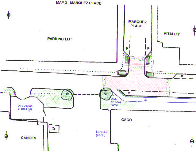
This section has the intersection with Marquez Place on
the top, and the entry to the Osco loading docks on the bottom. The
space on the bottom left mark the chainlink fence
behind which the canoe outfitters store their equipment. There currently
is no true curb in this area, just one big expanse of blacktop.
The building on the top right is Vitality. The space at the top
center and left is a parking lot, which serves state offices further to
the north on this lot. This lot currently has entrances onto Camino de
los Marquez (see previous detail map),
and Marquez Place.
Proposal:
As we approach from the
left there is a new curb on both the sout and north side, leaving 20' for
the road. On the south side, there is a curb cut giving access
to the canoe storage (unless that can be moved to the souteast corner of
the space). The new south
curb and sidewalk will leave a 36'-wide entrance to the loading dock area.
The intersection to Marquez Place is treated the same as the one to Cordova
Place: The entry is restricted to 21', with marked parking as shown on the
map. Plant boxes close to the corner emphasize the narrowed entrance.
Vitality, on the top right, is the first of a series of small businesses
facing Camino de los Marques. Most large trucks go no further than the
middle of this map. From here on east there is more pedestrian traffic, and
so we
want to slow traffic even more by raising the intersection, and a change
of pavement, indicated by the red hatched area.
Starting on this section, there is a 6' bi-directional bike path along the
south side. We decided to terminate the path here, since the south side of
Camino de los Marquez
west of this point is a mess of curb cuts, and there is not a lot of space.